20th Century Reanalysis

20CRv3 early access details

Created by laura.slivinski on - Updated on 02/23/2019 12:49

How to access preliminary NOAA-CIRES-DOE 20CRv3 data at the National Energy Research Scientific Computing Center (NERSC).


First, you must obtain an account at http://www.nersc.gov/users/accounts/user-accounts/get-a-nersc-account/  .
In the Description field of the account form, enter "I will be working with Gilbert Compo on analyses of the new NOAA-CIRES-DOE 20th Century Reanalysis version 3 using repo m958. I will be studying <your scientific interest goes here>." 


To see details on the model, assimilation, observations, and other implementation algorithms, click here.


Ensemble Mean and spread files in GRIB and text observation files are currently available on disk at NERSC:

/project/projectdirs/incite11/ensda_v451/ensda_[syear]/YYYYMMDDHH and

/project/projectdirs/20C_Reanalysis/ensda_v452/ensda_[syear]/YYYYMMDDHH, where:

  • 451 = 20CRv3si and 452 = 20CRv3mo

  • syear = “stream year” is any year from 1804 - 2009 ending in a 4 or a 9

  • Yearmonthdayhour directories are available every six hours (00,06,12,18)


Within a directory, there are several types of files. Consider the example 1916010100:

> l /project/projectdirs/incite11/ensda_v451/ensda_1914/1916010100

total 234240

drwxrwxr-x     2 cmccoll m958  131072 May 24 14:50 ./

drwxrwxr-x+ 8895 cmccoll m958   524288 Jul 24 17:08 ../

-rwxrwxr-x     1 cmccoll m958 15102002 Jan 11  2018 pgrbensmeananl_1916010100.grb2*

-rwxrwxr-x     1 cmccoll m958 16957694 Jan 11  2018 pgrbensmeananl_1916010103.grb2*

-rwxrwxr-x     1 cmccoll m958 16966630 Jan 11  2018 pgrbensmeanfg_1916010100_fhr06.grb2*

-rwxrwxr-x     1 cmccoll m958 57797749 Jan  3 2018 pgrbenssprdanl_1916010100*

-rwxrwxr-x     1 cmccoll m958 65366796 Jan  3 2018 pgrbenssprdanl_1916010103*

-rwxrwxr-x     1 cmccoll m958 65280022 Jan  3 2018 pgrbenssprdfg_1916010100_fhr06*

-rwxrwxr-x     1 cmccoll m958   90315 Jan 3 2018 psobfile*

-rwxrwxr-x     1 cmccoll m958   88308 Jan 3 2018 psobs.txt*

-rwxrwxr-x     1 cmccoll m958  149856 Jan 3 2018 psobs_posterior.txt*

-rwxrwxr-x     1 cmccoll m958   88977 Jan 3 2018 psobs_prior.txt*
 

pgrb” refers to grib (for spread files) or grib2 (for mean and everymember files) filetype.

anl” refers to “analysis”, and “fg” refers to “first guess”. Not all variables are available in all types of files. Accumulated and averaged variables are only available in pgrb files 3 hours after the central analysis time (in this example 00Z) and in the “fg” file valid 6 hours after the central analysis time.  Accumulations and averages are needed from both to make a 3 hourly timeseries. See below for more details.

psob* are each text files with observation statistics; psobs_posterior.txt is the final file with all statistics after completing the assimilation of observations at that time step. See link for specifics regarding each field in this file.


Examples for YYYMMDDHH = 2011010100:

pgrbensmeananl_YYYYMMDDHH.grb2 (pgrbanl, for short)

pgrbensmeananl_YYYYMMDD{HH+3}.grb2  (pgrbanl+3 for short)

pgrbensmeanfg_YYYYMMDDHH_fhr06.grb2  (pgrbfg for short)

Note that grib1 files (ie, ensemble spread files) will have the same variables, but may have different names depending on your reader.

In particular, note that precipitation rate is only in the pgrbfg* and pgrbanl+3. For YYYYMMDDHH = 2011010100 as above, note that the pgrbfg* file actually contains 3-hour average precipitation rate from 2010123121 to 2011010100, and the pgrbanl+3 contains the 3-hour average precipitation rate from  2011010100 to 2011010103.

This holds true for other average and accumulation variables.

Ensemble Mean and spread files in netCDF are currently available on disk at NERSC (to use nc tools run "load module nco")

Yearly files of 3 hourly or monthly mean fields for selected variables are currently being generated in 

/global/cscratch1/sd/cmccoll/ensmean_ncfiles_v451  
/global/cscratch1/sd/cmccoll/enssprd_ncfiles_v451
/global/cscratch1/sd/cmccoll/ensmean_ncfiles_v452  
/global/cscratch1/sd/cmccoll/enssprd_ncfiles_v452
 

As an example, files for Pressure at Mean Sea Level (PRMSL) are available from 1836 to 1980 in v451 directories and 1981 to 2015 in v452

ls /global/cscratch1/sd/cmccoll/ens*ncfiles*_v45?/PRMSL*

/global/cscratch1/sd/cmccoll/ensmean_ncfiles_v451/PRMSL.1836.mnmean_v451.nc
/global/cscratch1/sd/cmccoll/ensmean_ncfiles_v451/PRMSL.1836_v451.nc
...

/global/cscratch1/sd/cmccoll/ensmean_ncfiles_v452/PRMSL.2015.mnmean_v452.nc
/global/cscratch1/sd/cmccoll/ensmean_ncfiles_v452/PRMSL.2015_v452.nc
 

Ensemble Mean and spread files in netCDF available at NERSC’s high performance storage system (HPSS)

To see what is available in a given HPSS directory, login to Cori (or Edison),  and run “hsi ls /home/projects/incite11/[subdirectory]/”

possible subdirectory:

    ensda_v451_ensmean_netCDF

    ensda_v452_ensmean_netCDF

    ensda_v451_enssprd_netCDF

    ensda_v452_enssprd_netCDF

filenames: - VAR_Y1-Y10_ensmean_v451.tar

                    VAR_Y1-Y10_enssprd_v451.tar

        VAR is the variable

         For V451 Y1-Y10 can be 1836-1845,1846-1855,1856-1865...1976-1980

         For V452 Y1-Y10 can be 1981-1990,1991-2000,2001-2010,2011-2015

example:

/home/projects/incite11/ensda_v451_ensmean_netCDF/WEASD_1976-1985_ensmean_v451.tar


Individual ensemble members, as well as mean and spread files, are available on NERSC’s high performance storage system (HPSS)


Example workflow from Philip Brohan that accesses a few selected variables and converts every member to netCDF

Example workflow of Chesley McColl that accesses 85 selected variables and converts every member to netCDF

Example workflow of Chesley McColl that access 85 selected variables and converts ensemble mean and spread to netCDF


To see what is available in a given HPSS directory, login to Cori (or Edison),  and run “hsi ls /home/projects/incite11/[subdirectory]/”

To see all files within a tarball, use “htar -tvf [hpss directory]/[tarball].tar".  

See below for relevant paths and tarball names.


Details of access for every-member netCDF files on the HPSS (currently in progress):

***Note: These directories are incomplete.  This post-processing is in progress, so some years may be complete, but many are not.

For 1836 - 1980:

/home/projects/incite11/20CR_v3_451_ncfiles/[variable]/

For 1981 onward:

/home/projects/incite11/20CR_v3_452_ncfiles/[variable]/

Each of these directories contains every-member 3-hourly netCDF files for a single year in the form [variable]_[YYYY]_v3.tar, as well as every-member monthly mean netCDF files for a single year in the form [variable]_[YYYY]_mnmean_v3.tar.

For example, /home/projects/incite11/20CR_v3_451_ncfiles/PRMSL/PRMSL_1901_v3.tar contains PRMSL.1901_mem001.nc through PRMSL.1901_mem080.nc. Each of these netCDF files contains the 3-hourly Pressure Reduced to Mean Sea Level for all of 1901 for the given member.


Details of access for every-member grib files on the HPSS: 
 

For 1836 - 1980:

/home/projects/incite11/ensda_v451_archive_grb2_monthly/ensda_451_[syear]/[YYYY]/  

For 1981 onward (as of 11 Oct 2018, 2015 is finished):

/home/projects/incite11/ensda_v452_archive_grb2_monthly/ensda_452_[syear]/[YYYY]/

Recall “syear” will end in a 4 or a 9, and production years within that directory will start 1 January two years after syear.  So, /home/projects/incite11/ensda_v451_archive_grb2_monthly/ensda_451_1859/

contains years 1861 - 1865, and /home/projects/incite11/ensda_v451_archive_grb2_monthly/ensda_451_1864/

contains years 1866 - 1870.


To access, login to a NERSC data transfer node (dtn01.nersc.gov or dtn02.nersc.gov), cd to the directory where you want the data (probably in $SCRATCH) and run “htar -xvf /home/projects/incite11/ensda_v451_archive_grb2_monthly/ensda_451_[syear]/[YYYY]/[tarball].tar” .

To see all tarballs within a directory, run “hsi ls /home/projects/incite11/ensda_v451_archive_grb2_monthly/ensda_451_[syear]/[YYYY]/”


Within each [YYYY] directory, each individual ensemble member (01 - 80) for each month is tar’d up, as well as the ensemble statistics. Note that each YYYYMM tarball still includes 3-hourly (pgrbanl, sflx)  or 6-hourly (pgrbfg, psobs) files within it, NOT monthly means.

YYYYMM_pgrbanl_mem0**.tar

YYYYMM_pgrbfg_mem0**.tar

YYYYMM_pgrbensmean.tar

YYYYMM_pgrbenssprd.tar

YYYYMM_sflxgrbensmean.tar  (includes sflxgrbensmeanfg_YYYYMMDDHH_fhr03.grb and sflxgrbensmeanfg_YYYYMMDDHH_fhr06.grb; see links below.)

YYYYMM_sflxgrbenssprd.tar

YYYYMM_psobs.tar (includes observation diagnostic files psobfile, psobs.txt, psobs_prior.txt, and psobs_posterior.txt; see above link for descriptions.)


Examples for YYYYMMDDHH = 2016010106:

sflxgrbensmeanfg_2016010106_fhr03.grb (includes accum. variables from 0-3Z)

sflxgrbensmeanfg_2016010106_fhr06.grb (includes accum. variables from 3-6Z)

NOTE: There is an unresolved issue where some sflxgrbensmean files include two extra variables than other files (pressure at convective cloud top and pressure at convective cloud bottom.) We are unsure of the extent of this problem.


If everymember sflx files are necessary, then one needs to access the HPSS directories /home/projects/incite11/ensda_v451_archive_orig and

/home/projects/incite11/ensda_v452_archive_orig


Within /home/projects/incite11/ensda_v451_archive_orig/ensda_451_[syear] are the six-hourly tarballs with everything.  For example:

/home/projects/incite11/ensda_v451_archive_orig/ensda_451_1904/1906020106.tar includes:

sanl_1906020106_fhr0[3,6]_mem0[01..80] + ensmean (spectral model file converted to grib)

pgrbfg* everymember and ensemble statistics (all in grib1)

pgrbanl for 1906020106 and 1906020109

psob* files

sflxgrb_1906020106_fhr0[0,3,6,9]_mem0[01..80]

sflxgrbensmeanfg_1906020106_fhr03

sflxgrbensmeanfg_1906020106_fhr06

sflxgrbenssprdfg_1906020106_fhr03

sflxgrbenssprdfg_1906020106_fhr06


Note: all dates 1, 10, 20 (and some 5, 15, 25) at 00Z will have extra files (needed to back up and restart the model.)

For example, /home/projects/incite11/ensda_v451_archive_orig/ensda_451_1904/1906020100.tar includes:

bfg_1906020100_fhr0[0,3,6,9]_mem0[01..80] + ensmean (spectral model file)

sfg_1906020100_fhr0[0,3,6,9]_mem0[01..80] + ensmean (spectral model file)

sanl_1906020100_fhr0[3,6]_mem0[01..80] + ensmean (spectral model file converted to grib)

sfcanl_1906020100_fhr0[3,6]_mem0[01..80]+ ensmean  (spectral model file)

pgrbfg* everymember and ensemble statistics (all in grib1)

pgrbanl for 1906020100 and 1906020103

psob* files

sflxgrb_1906020100_fhr0[0,3,6,9]_mem0[01..80]

sflxgrbensmeanfg_1906020100_fhr03

sflxgrbensmeanfg_1906020100_fhr06

sflxgrbenssprdfg_1906020100_fhr03

sflxgrbenssprdfg_1906020100_fhr06
 

Add new comment

CAPTCHA
This question is for testing whether or not you are a human visitor and to prevent automated spam submissions.

Temperature trends for the period 1871-2009 in the midlatitude summer mesosphere

Created by baumgarten on - Updated on 08/09/2016 11:27

Lübken, F.-J., U. Berger, and G. Baumgarten (2013),

Temperature trends in the midlatitude summer mesosphere,

J. Geophys. Res. Atmos., 118, doi: 10.1002/2013JD020576.

A trend analysis of long term runs have been performed with the LIMA model (0-150 km altitude) applying the NOAA-CIRES 20th Century Reanalysis (V2) from 2009 back to 1871. LIMA adapts the Reanalysis data (u,v,T) with global coverage every 6 hour below about 25 km applying a nudging method. Variations of green house gases CO2 and O3 have been predescribed according to observations. Trends have been estimated in the troposphere, stratosphere, and mesosphere at mid-latitudes for summer conditions (June - August).

As a main result trends are non-uniform with time.

Since the late 19th century, temperatures in the mesosphere have dropped by up to 5-7 K (10-12 K) on pressure (geometric) altitudes.

This is much more than typical trends in the troposphere and stratosphere. The summer mesosphere therefore reacts much more sensitive to climate change compared to lower altitudes.

Short summary:

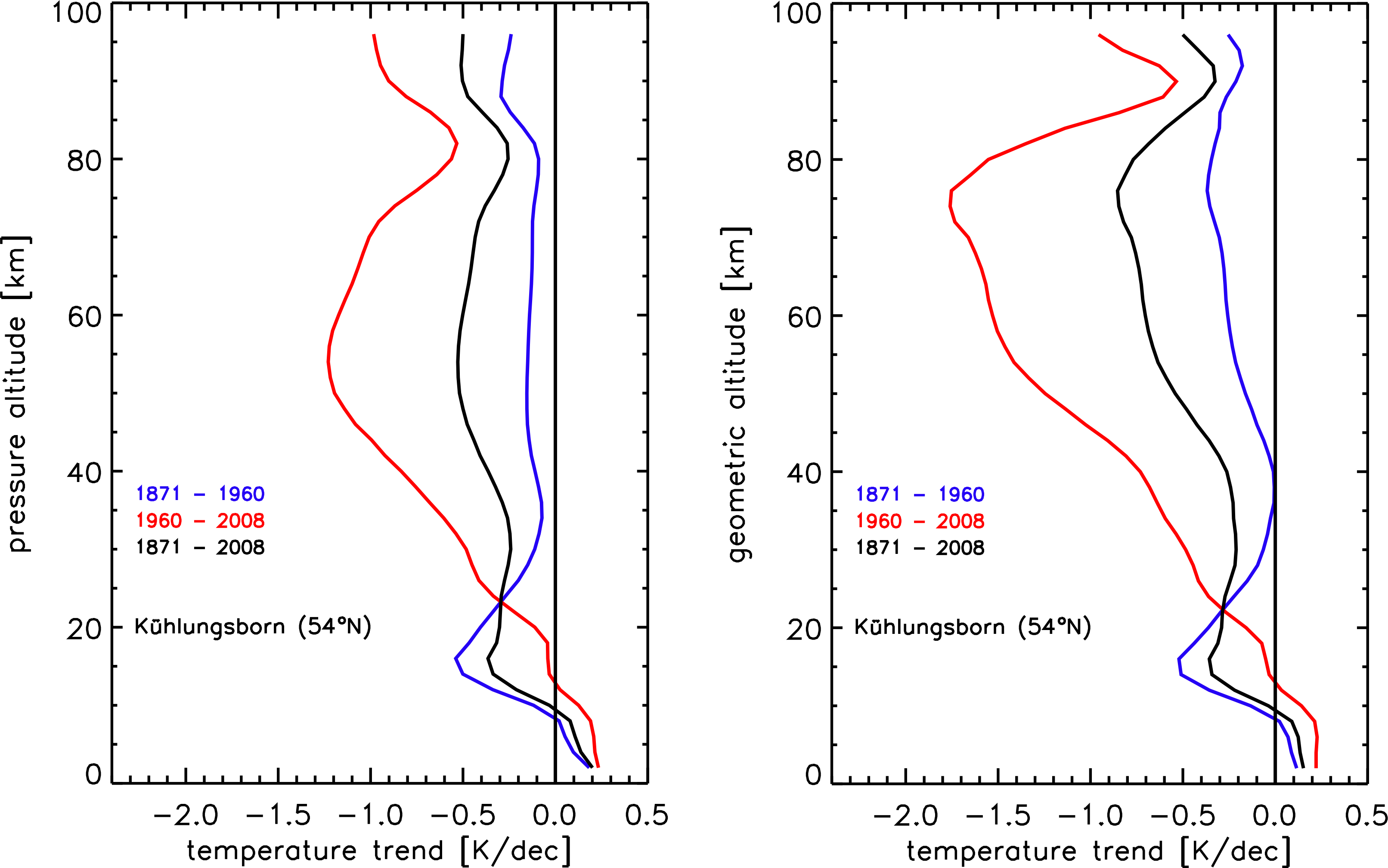
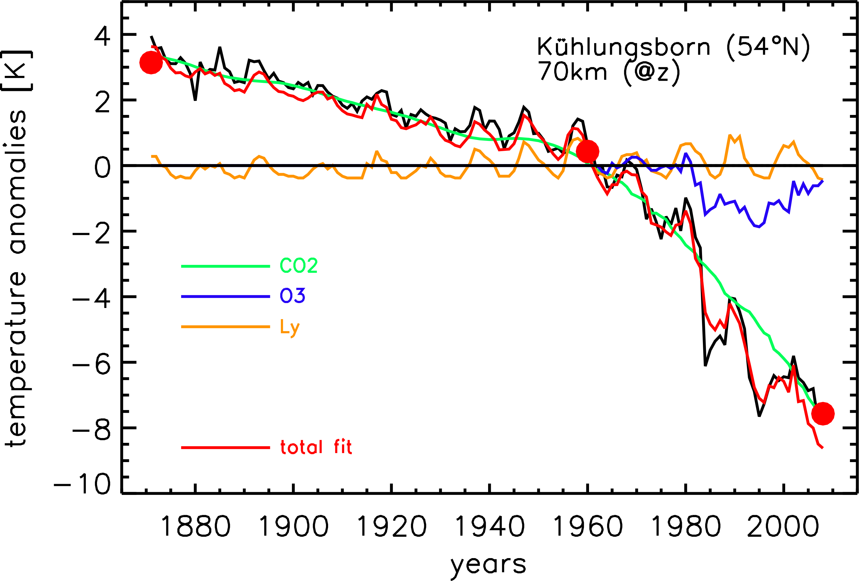
In Fig. 1 we show mean June to August temperatures at 54°N from LIMA at geometric height of 70 km based on NOAA-CIRES 20th Century Reanalysis. We have performed a multivariate fit based on three functions (also shown in Fig. 1), namely CO2(t), O3(t), and Ly-alpha(t). The largest contribution to the long term temperature trend comes from CO2, whereas O3 has an impact in the last 30 years only (by construction), and Ly-alpha(t) causes a quasi-periodical modulation. Obviously, temperature trends are not uniform in time but accelerate since approximately the 1960s. Comparison with CO2(t) clearly shows that this acceleration is due to an increase of carbon dioxide. We have calculated temperature trends in three periods, namely from the beginning of the time series (1871) to 1960, from 1960 to present time (2008), and over the entire period. The results are shown in Fig. 2. As expected, trends are larger in the second period. In pressure coordinates, total temperature trends are largest in the upper stratosphere and mesosphere, more precisely at 40-70 km. Trends are minimal around the mesopause. In geometric heights, trends are generally larger and, for the second period 1960-2008, clearly maximize in the mesosphere, where trends can be as large as -1.8 K/dec. We note that this trend analysis produces very similar results in comparison with a detailed trend analysis using ECMWF reanalysis data in the period 1961-2009 (for more details, see Lübken et al, JGR, 2013).


Fig.1: Temperature anomalies (=deviations from the June-August 1871-2009 mean) at zgeo=70 km at 54°N (Kühlungsborn, Germany) from 1871 to 2008 (black line). The result of a multivariate fit (red) consisting of CO2(t) (green), O3(t) (blue), and Ly-alpha(t) (orange) is also shown. Temperatures are marked at the beginning and at the end of the time series, and around 1960 where the trend changes markedly (red dots).


Fig.2: Temperature trends (June-August) for the location of Kühlungsborn 54°N) as a function of pressure (left) and geometric (right) altitudes. Black lines show the trend over the entire period (1871-2008), whereas blue and red lines show trends in the subperiods 1871-1960 and 1960-2008, respectively.

gilbert.p.comp…

Wed, 01/08/2014 - 13:04

Dear Dr. Lübken, Very interesting! Looking at your paper, I don't see how the temperature biases in the 20CR stratosphere were handled. (see, e.g., Fig. A1 in Compo et al. 2011, (available at http://onlinelibrary.wiley.com/doi/10.1002/qj.776/abstract ) Do you think that the biases might have an impact on your results? Also, how similar are the trends in the latter period to your results using ECWMF reanalyses in your paper Fig. 10? best wishes, gil compo U. of Colorado/CIRES & NOAA Earth System Research Laboratory

Add new comment

CAPTCHA
This question is for testing whether or not you are a human visitor and to prevent automated spam submissions.

20CR: ensemble mean wind-speeds appear wrong

Created by Neil.Swart on - Updated on 08/09/2016 11:28

I suspect that the 20CR.v2 ensemble mean wind speeds provided publicly were calculated incorrectly, and I will briefly explain.

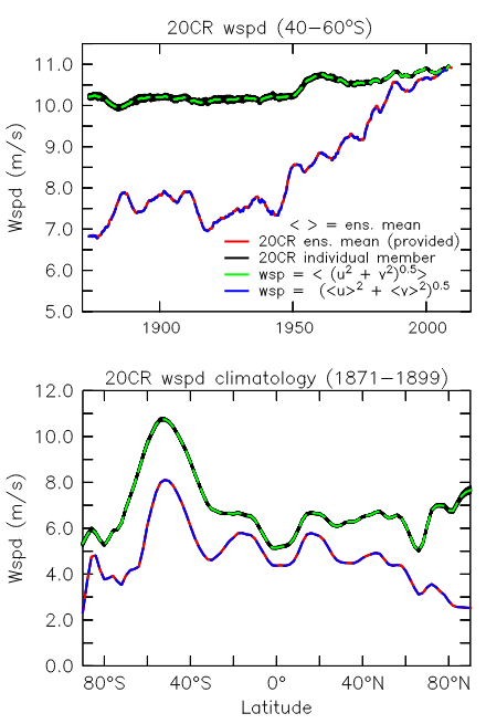
As confirmed in the attached plots, the ensemble mean speeds provided for 20CR were computed as:

wspd = [<u>^2 +<v>^2]0.5


where <> indicates the ensemble mean. The correct calculation would be


wspd = < [u2 + v2]0.5 >


As you can see in the attached, the provided ensemble mean speeds look nothing like the speeds in the individual ensemble members, and appear  wrong.

After downloading all the individual ensemble members and recalculating the speeds using the correct formula above, I get an ensemble mean which is perfectly

consistent with the individual members (i.e. falls in the middle of them), as would be expected.

The ensemble mean wind speeds provided also look physically unrealistic (e.g. too low at extratropical latitudes prior to the 1990's), and exhibit unrealistically

large trends. When using the individual ensemble members, or the correctly re-calculated ensemble mean speed, these issues are corrected.

I suspect many users could be affected by this, and I hope that this info might be useful.

-Neil Swart


(top) 20CR.v2 wind-speeds at sig0995 averaged over 40 to 60 S and smoothed with a 5-year wide boxcar (bottom) 20CR.v2 wind-speed climatology over 1871 to 1899. Wind speeds are shown for the provided ensemble mean monthly speeds (from ESRL), and as calculated from the daily u and v components of the individual ensemble members (downloaded from NERSC). Also shown are two different computation of the ensemble mean derived from the individual members, computed as per the formula in the figure key.


Note in the time-series plot attached the data are all smoothed with a 5-year wide boxcar. 

Neil.Swart

Mon, 11/25/2013 - 10:47

I also have a question:

Can you confirm whether this issue might affect the wind-stress fields too?

I.e.: Calculating the ensemble mean stress as

tauu = ^2

instead of

tauu = < u^2 >

Or are the stess fields computed online in the model from the instantaneous U and V and therefore okay?

Neil.Swart

Mon, 11/25/2013 - 10:39

Hi Gil,

In these calculations using all the individual ensemble memebers I was only considering the sigma .995 level winds. I have also looked in some detail
at the 10 m winds - at least at the ensemble mean 10m winds downloaded from ESRL. My guess is that the same issue affects the 10 m wind
speeds, because they also exhibit the (unrealistically) large trends in time, as seen in the sigma .995 winds above.

That said, I cannot confirm this by performing the same calculation with the 10m winds, because the individual ensemble members for the 10 m winds
are not available on the nersc.gov site, as far as I can see.

-Neil

Neil, 10 m winds are at the portal.nersc.gov site in netCDF4. They are under the "first_guess" directories. For example, for the 10 m zonal wind http://portal.nersc.gov/pydap/20C_Reanalysis_ensemble/first_guess/u10m/ These are also OPeNDAP enabled. The "derived" directories at http://portal.nersc.gov/pydap/20C_Reanalysis_ensemble/ have the daily and monthly averages for each member. Additional selected variables are available from the NERSC Tape Science Gateway in GRIB format: http://portal.nersc.gov/archive/home/projects/incite11/www/20C_Reanalysis/everymember_grib_indi_fg_variables and 3 dimensional and surface grids in GRIB format for most years at http://portal.nersc.gov/archive/home/projects/incite11/www/20C_Reanalysis/everymember_full_analysis_fields Note that the first guess is not directly incremented by the observations. It is the product of the numerical weather prediction model forecast initialized from the analyzed state. Please let me know if I can be of more help. best wishes, gil

Neil.Swart

Fri, 11/22/2013 - 14:50

Hi Cathy,
Thats good to know, thanks. The resulting wind-speed errors are not small, but in fact are very large (>3m/s or 50% in some cases).
You can see that very clearly in my figure - but I'm having trouble getting that to show up in the post. SOrry but I'm a noob at editing these pages!

Cathy.Smith@noaa.gov

Fri, 11/22/2013 - 14:43

We will look at calculating the values from the individual ensemble members. You are correct the wind speed from the ensemble means would be lower than that of the average wind speed of the ensemble members and it would be most different where the ensemble members were most different from each other. We don't have the wind speed file listed in our docs but it is in /Datasets/ I'll remove the files and document this. I'm not sure when we can generate the re-computed files.

Add new comment

CAPTCHA
This question is for testing whether or not you are a human visitor and to prevent automated spam submissions.

An intercomparison of different cloud climatologies in the Arctic

Created by chernav on - Updated on 08/09/2016 11:45

A recent publication on different Arctic cloud climatologies intercomparison shows a wide spread among observations and reanalyses. Reanalyses generally are not in a close agreement with satellite and surface observations of cloudiness in the Arctic. Several reanalyses show the highest values of total cloud fraction over the central part of the Arctic Ocean but not over the Norwegian Sea and the Barents Sea as observations do. The maximum and minimum of total cloud fraction in the annual cycle are shifted by 1-2 months compared to observations.


December-January-February and June-July-August mean of TCF over the Arctic (north of 60◦N) from different data.


The annual cycle of TCF.


Normalized pattern statistics showing differences among different observational and reanalyses TCF spatial distribution (Taylor diagrams).


Alexander Chernokulsky and Igor I. Mokhov, “Climatology of Total Cloudiness in the Arctic: An Intercomparison of Observations and Reanalyses,” Advances in Meteorology, vol. 2012, Article ID 542093, 15 pages, 2012. doi:10.1155/2012/542093

Add new comment

CAPTCHA
This question is for testing whether or not you are a human visitor and to prevent automated spam submissions.

International Surface Pressure Databank Contributing Organizations

Created by gilbert.p.comp… on - Updated on 10/07/2019 19:45

Back to ISPD homepage

  1. All-Russian Research Institute of Hydrometeorological Information World Data Center
  2. Atmospheric Circulation Reconstructions over the Earth (ACRE)
  3. Australian Bureau of Meteorology
  4. Australian Meteorological Association, Citizen Science team
  5. British Antarctic Survey
  6. China University of Geosciences
  7. China Meteorological Administration
  8. Cook Islands Meteorological Service
  9. Danish Meteorological Institute
  10. Deutscher Wetterdienst (DWD; German Weather Service)
  11. Environment Canada, Climate Research Division
  12. ETH Zurich, Switzerland
  13. European and North Atlantic Daily to Multidecadal Climate Variability (EMULATE)
  14. European Reanalysis and Observations for Monitoring (EURO4M)/The WMO MEditerranean DAta REscue Initiative (MEDARE)
  15. European Reanalysis of Global Climate Observations (ERA-CLIM)
  16. GCOS Atmospheric Observation and Ocean Observation Panels for Climate WG on Surface Pressure
  17. GCOS/WCRP Working Group on Observational Data Sets for Reanalysis
  18. Hong Kong Observatory
  19. Icelandic Meteorological Office (IMO)
  20. International Best Track Archive for Climate Stewardship (IBTrACS)
  21. International Comprehensive Ocean–Atmosphere Data Set (ICOADS)
  22. International Environmental Data Rescue Organization (IEDRO)
  23. Japan Agency for Marine-Earth Science and Technology (JAMSTEC)
  24. Japan Meteorological Agency
  25. Jersey Met Department
  26. Koninklijk Nederlands Meteorologisch Instituut (KNMI; Royal Netherlands Meteorological Institute)
  27. Lamont-Doherty Earth Observatory of Columbia University
  28. McGill University, Canada
  29. Met Office Hadley Centre, UK
  30. MetéoFrance
  31. MeteoFrance—Division of Climate
  32. Meteorological and Hydrological Service, Croatia
  33. National Center for Atmospheric Research (NCAR), USA
  34. National Climate Center, Beijing, China
  35. National Institute for Water and Atmospheric Research (NIWA), New Zealand
  36. Nicolaus Copernicus University—Department of Meteorology and Climatology, Poland
  37. Niue Meteorological Service
  38. NOAA Climate Database Modernization Program (CDMP), USA
  39. NOAA Earth System Research Laboratory (ESRL) Physical Sciences Division, USA
  40. NOAA Midwest Regional Climate Center at UIUC, USA
  41. NOAA National Centers for Environmental Prediction (NCEP), USA
  42. NOAA National Centers for Environmental Information (NCEI), USA
  43. NOAA Northeast Regional Climate Center at Cornell Univ., USA
  44. NOAA Pacific Marine Environmental Laboratory, USA
  45. Norwegian Meteorological Institute
  46. Ohio State Univ.—Byrd Polar Research Center, USA
  47. Oldweather.org
  48. Portguese Institute of Sea and Atmosphere (IPMA), Portugal
  49. Proudman Oceanographic Laboratory, UK
  50. Signatures of environmental change in the observations of the Geophysical Institutes (SIGN)
  51. South African Weather Service
  52. South Eastern Australian Recent Climate History (SEARCH) project, The University of Melbourne
  53. Tanzania Meteorological Agency
  54. Univ. of Aberdeen, Scotland, UK
  55. Univ. of Bern, Switzerland
  56. Univ. of ColoradoCooperative Institute for Research in Environmental Sciences (CIRES)
  57. Univ. of East Anglia—Climatic Research Unit, UK
  58. Univ. of GiessenDepartment of Geography, Germany
  59. Univ. of Lisbon—Instituto Dom Luiz, Portugal
  60. Univ. of Milan—Department of Physics, Italy
  61. Univ. of Porto-Instituto Geofisico, Portugal
  62. Univ. Rovira i Virgili—Center for Climate Change (C3), Spain
  63. Univ. of South Carolina, USA
  64. Univ. of Toronto-Department of Physics, Canada
  65. Univ. of Washington, USA
  66. Weather Detective citizen science project
  67. WeatherRescue.org
  68. World Meteorological Organization-Mediterranean Climate Data Rescue (MEDARE)
  69. ZentralAnstalt für Meteorologie und Geodynamik (ZAMG; Austrian Weather Service)

Back to ISPD homepage

Add new comment

CAPTCHA
This question is for testing whether or not you are a human visitor and to prevent automated spam submissions.

The International Surface Pressure Databank

Created by tcram on - Updated on 06/25/2024 14:24

The International Surface Pressure Databank

 
Created by tcram on Thu, 05/19/2011 - 16:31 - Updated on 07/24/2020 11:16

The International Surface Pressure Databank (ISPD, Cram et al. 2015) is the world's largest collection of pressure observations. It spans 1722-2015. It has been developed by extracting observations from established international archives of meteorological variables and by combining these with observations made available through additional international cooperation with data recovery facilitated by the Atmospheric Circulation Reconstructions over the Earth (ACRE) Initiative and the other contributing organizations. The ISPD is assembled under the auspices of the GCOS Working Group on Surface Pressure and the GCOS/WCRP Working Group on Observational Data Sets for Reanalysis by NOAA Earth System Research Laboratory (ESRL), NOAA's National Centers for Environmental Information (NCEI), and the University of Colorado's Cooperative Institute for Research in Environmental Sciences (CIRES).  

The ISPD consists of three components: station observations, marine observations, and tropical cyclone best track pressure reports.

The station component is a blend of many national and international collections, with the largest contributor being surface and sea level pressure observations from the International Surface Database (ISD, Lott et al., 2008). Procedures for blending the station component are described at Yin et al. (2008).

The marine component consists of the available version of the International Comprehensive Ocean Atmosphere Data Set (ICOADS, Worley et al., 2005). In some ISPD versions, ICOADS Auxiliary data, ACRE recovered expeditions, and Oldweather.org data are also used.

The tropical cyclone component comes mainly from the available version of the International Best Track Archive for Climate Stewardship (IBTrACS, Knapp et al., 2010). In the absence of a central pressure estimate, IBTrACS wind estimates are converted to pressure using an empirical gradient wind equation (Compo et al. 2011).


To submit station observations, please submit your observations to NOAA's National Center for Environmental Information via Xungang.Yin@noaa.gov using the ASCII exchange format v1.0.

Version 5 (1755-2012)

Version 5 of the International Surface Pressure Databank is currently being assembled. 
 

Additional guidelines for station data submission are under development.

Version 4 (1836-2015)

Version 4 of the ISPD is available courtesy of the Research Data Archive of the Computational and Information Systems Laboratory (CISL) at the National Center for Atmospheric Research (NCAR) from http://rda.ucar.edu/datasets/ds132.2/. Subsetting tools are available to retrieve the data in ASCII format. Documentation for the HDF5 format is provided at https://rda.ucar.edu/datasets/ds132.2/index.html#!docs.  Users can also browse an interactive map displaying observation locations by type, date, and region using the NCAR Interactive Station Viewer at https://rda.ucar.edu/datasets/ds132.2/index.html#wstationViewer.

NOAA's National Centers for Environmental Information has merged the station component using the ASCII exchange format v1.1.  The marine component comes from ICOADS version 3+, with enhancements to ICOADS version 3 from ACRE, Oldweather.org and Weather Detective courtesy of P. Brohan of the UK Met Office. The tropical cyclone component comes mainly from IBTrACS V03r10. See Slivinski et al. 2019 for details.

Maps showing the location of stations in a selected year can be browsed at https://psl.noaa.gov/data/ISPD/.

Maps showing the location of observations used in 20CRV3 in a selected year can be browsed at https://psl.noaa.gov/data/20CRv3_ISPD_obscounts/

Maps showing the location of all available, rejected, and assimilated observations used in 20CRV3 in a selected month can be browsed at https://psl.noaa.gov/data/20CRv3_ISPD_obscounts_bymonth/

The V4 list of stations, including location and period of coverage, and their history is a text file that can be imported into Excel or read into other programs using this format.

DOI: 10.5065/9EYR-TY90

Citation: Compo, G. P., et al. 2019. The International Surface Pressure Databank version 4. Research Data Archive at the National Center for Atmospheric Research, Computational and Information Systems Laboratory. https://doi.org/10.5065/9eyr-ty90. Accessed § dd mmm yyyy.
  §Please fill in the "Accessed" date with the day, month, and year (e.g. - 5 Aug 2011) you last accessed the data from the NCAR Research Data Archive.


Version 3 (1755-2011)

Version 3 of the ISPD is available courtesy of the Research Data Archive of the Computational and Information Systems Laboratory (CISL) at the National Center for Atmospheric Research (NCAR) from http://rda.ucar.edu/datasets/ds132.1/. NCAR also has documentation on the HDF5 Format for International Surface Pressure Data Bank v10.11.

NOAA's National Climatic Data Center has merged the station component using the ASCII exchange format v1.1.  The marine component comes from ICOADS version 2.5. The tropical cyclone component comes from IBTrACS V03r03. ISPDv3 is being used in the century long reanalysis ERA-20C generated by ERA-CLIM,  by the century long reanalysis being generated by JMA/MRI, and by NOAA/CIRES in 20CR version 2c.

Maps showing the location of stations in a selected year can be browsed at http://www.esrl.noaa.gov/psd/data/ISPD/v3.0/
The V3 list of stations, including location and period of coverage, and their history is a text file that can be imported into Excel or read into other programs using this format.

DOI: 10.5065/D6D50K29

Citation: Compo, G. P., et al. 2015. The International Surface Pressure Databank version 3. Research Data Archive at the National Center for Atmospheric Research, Computational and Information Systems Laboratory. http://dx.doi.org/10.5065/D6D50K29. Accessed § dd mmm yyyy.
  §Please fill in the "Accessed" date with the day, month, and year (e.g. - 5 Aug 2011) you last accessed the data from the NCAR Research Data Archive.


Version 2 (1768-2012)

Version 2 of the ISPD can be obtained courtesy of Data Engineering and Curation Section of the Computational and Information Systems Laboratory at the National Center for Atmospheric Research from http://rda.ucar.edu/datasets/ds132.0/. NCAR also has documentation on the HDF5 Format for International Surface Pressure Data Bank v10.11.

For the period 1871-2011, Version 2 includes metadata information from the quality control system of the 20th Century Reanalysis Project. These so-called "feedback" records include the difference between the final analysis and each observation, the estimated uncertainty in the observation, and other quality information.

See Compo et al. (2011) and Cram et al. (2015) for a more detailed description. 

Maps showing the location of stations in a selected year can be browsed at http://www.esrl.noaa.gov/psd/data/ISPD/v2.0/.
The V2 list of stations, including location and period of coverage, and their history is a text file that can be imported into Excel or read into other programs using this format.

DOI:10.5065/D6SQ8XDW

Citation: Compo, G. P., et al. 2010. International Surface Pressure Databank (ISPDv2). Research Data Archive at the National Center for Atmospheric Research, Computational and Information Systems Laboratory. http://dx.doi.org/10.5065/D6SQ8XDW. Accessed§ dd mmm yyyy.
  §Please fill in the "Accessed" date with the day, month, and year (e.g. - 5 Aug 2011) you last accessed the data from the NCAR Research Data Archive.

      Future Additions

         At http://badc.nerc.ac.uk/browse/badc/corral/images/metobs there any many useful links to information about known observations and their recovery status. The site has links to scanned images of hard copy meteorological observations held by the National Meteorological Archive of the UK Met Office that have been imaged to date. It also has an EXCEL file containing the status of all of the historical weather data (whether hard copy, scanned or digitised) being recovered, imaged, and digitised by the international ACRE community and international organisations projects and researchers linked to the Initiative for the ISPD. Additionally, the site has annual global maps showing terrestrial weather data distribution and their status.

Guidelines for station data submission

Data Access

The International Surface Pressure Databank would like to thank the contributing organizations and make many grateful acknowledgments. Support for the compilation of the ISPD is provided by the National Oceanic and Atmospheric Administration Climate Program Office and SwissRe.

The 20th Century Reanalysis Project used resources of the National Energy Research Scientific Computing Center and of the Oak Ridge Leadership Computing Facility at Oak Ridge National Laboratory, which are supported by the Office of Science of the U.S. Department of Energy under Contract No. DE-AC02-05CH11231 and Contract No. DE-AC05-00OR22725, respectively. Support for the 20th Century Reanalysis Project dataset is provided by the U.S. Department of Energy, Office of Science Innovative and Novel Computational Impact on Theory and Experiment (DOE INCITE) program, and Office of Biological and Environmental Research (BER), by the National Oceanic and Atmospheric Administration Climate Program Office, and by NOAA Earth System Research Laboratory Physical Sciences Division.

References:

Compo, G.P., J.S. Whitaker, P.D. Sardeshmukh, N. Matsui, R.J. Allan, X. Yin, B.E. Gleason, R.S. Vose, G. Rutledge, P. Bessemoulin, S. Brönnimann, M. Brunet, R.I. Crouthamel, A.N. Grant, P.Y. Groisman, P.D. Jones, M. Kruk, A.C. Kruger, G.J. Marshall, M. Maugeri, H.Y. Mok, Ø. Nordli, T.F. Ross, R.M. Trigo, X.L. Wang, S.D. Woodruff, and S.J. Worley, 2011: The Twentieth Century Reanalysis Project. Quarterly J. Roy. Meteorol. Soc., 137, 1-28. DOI: 10.1002/qj.776.

Cram, T.A., G. P. Compo, X. Yin, R. J. Allan, C. McColl, R. S. Vose, J.S. Whitaker, N. Matsui, L. Ashcroft, R. Auchmann, P. Bessemoulin, T. Brandsma, P. Brohan, M. Brunet, J. Comeaux, R. Crouthamel, B. E. Gleason, Jr., P. Y. Groisman, H. Hersbach, P. D. Jones, T. Jonsson, S. Jourdain, G. Kelly, K. R. Knapp, A. Kruger, H. Kubota, G. Lentini, A. Lorrey, N. Lott, S. J. Lubker, J. Luterbacher, G. J. Marshall, M. Maugeri, C. J. Mock, H. Y. Mok, O. Nordli, M. J. Rodwell, T. F. Ross, D. Schuster, L. Srnec, M. A. Valente, Z. Vizi, X. L. Wang, N. Westcott, J. S. Woollen, S. J. Worley, 2015: The International Surface Pressure Databank version 2. Geoscience Data Journal, 2, 31-46. DOI: 10.1002/gdj3.25.

Knapp KR, Kruk MC, Levinson DH, Diamond HJ, Neumann CJ, 2010: The International Best Track Archive for Climate Stewardship (IBTrACS): Unifying tropical cyclone best track data. Bull. Amer. Meteorol. Soc.91: 363376. DOI: 10.1175/2009BAMS2755.1.

Lott N, Vose R, Del Greco SA, Ross TF, Worley S, Comeaux J. 2008. ‘The Integrated Surface Database: Partnerships and progress.’ In Proceedings of 88th AMS Annual Meeting, 20–25 January 2008, New Orleans, Louisiana, combined preprints (CD-ROM), Amer. Meteorol. Soc: Boston, MA. Available from http://www1.ncdc.noaa.gov/pub/data/ish/ams-isd-jan08.pdf.

McColl, C., X. Yin, G. Compo, R. Allan, R. Vose, S. Woodruff, K. Knapp, and T. Cram, 2011: Assembling the International Surface Pressure Databank. World Climate Resarch Programme Open Science Conference, Denver, USA, 24 October. Poster link.

Slivinski, L. C., Compo, G. P., Whitaker, J. S., Sardeshmukh, P. D., Giese, B. S., McColl, C., Allan, R., Yin, X., Vose, R., Titchner, H., Kennedy, J., Spencer, L. J., Ashcroft, L., Brönnimann, S., Brunet, M., Camuffo, D., Cornes, R., Cram, T. A., Crouthamel, R., Domínguez‐Castro, F., Freeman, J. E., Gergis, J., Hawkins, E., Jones, P. D., Jourdain, S., Kaplan, A., Kubota, H., Le Blancq, F., Lee, T., Lorrey, A., Luterbacher, J., Maugeri, M., Mock, C. J., Moore, G. K., Przybylak, R., Pudmenzky, C., Reason, C., Slonosky, V. C., Smith, C., Tinz, B., Trewin, B., Valente, M. A., Wang, X. L., Wilkinson, C., Wood, K. and Wyszyński, P. (2019), Towards a more reliable historical reanalysis: Improvements for version 3 of the Twentieth Century Reanalysis system. Q J R Meteorol Soc. (accepted) doi:10.1002/qj.3598.

Worley SJ, Woodruff SD, Reynolds RW, Lubker SJ, Lott N. 2005. ICOADS release 2.1 data and products. Int. J. Climatol.25: 823842. DOI: 10.1002/joc.1166.

Yin X, Gleason BE, Compo GP, Matsui N, Vose RS, 2008: The International Surface Pressure Databank (ISPD) land component version 2.2.  National Climatic Data Center, Asheville, NC. Available from ftp://ftp.ncdc.noaa.gov/pub/data/ispd/doc/ISPD2_2.pdf or from this site.

Yvan Dutil (not verified)

Sat, 08/30/2014 - 10:15

Checking the map of the V4, the deepest in time we could expect to do a decent continuous North Atlantic Climate reanalysis using ISPD alone would be 1828. At this moment 1800, seams to be a hard limit to do any reanalysis at all for Europe. Unfortunately, they appears to be very little weather data available before 1850 not yet uncovered that could significantly improve this situation. I assume the 20CR version 2C is using a database close to the version 4. In consequence, the 1871 spatial coverage will be significantly extended compared to version 2. For 1850, the reanalysis will be comparable to the reanalysis for 1871 of the version 2.

Dear Yvan, As presented at the recent ACRE workshop in Toronto (proceedings will be online soon), the 20CRv2c currently being generated is using ISPDv3 not version 4, which is still being merged. You can access annual maps of the version 3 station component at http://www.esrl.noaa.gov/psd/data/ISPD/ . Note that these are not quite the version 3.2.9 that 20CRv2c is using, which has additional coverage over New Zealand, for example. Even so, the 1871 coverage is a substantial improvement over ISPDv2 used in 20CRv2. As to coverage before 1828, our ACRE colleagues continue to uncover new sources, so I would not rule out additional stations being digitized for that period.

Thank's for the prompt answer. Actually, I did notice that ISPDv4 map did not match with Phil Brohan visualisation of 20CR version 2C, after posting my comment. I did also notice that many potential sites on the ISPD 2.2.4 map are not yet included in the version 4. I assume the 20CR version 3 will be able to use version 4 or better.

Yvan, Correct. We expect 20CRv3 to use ISPDv4 or later. Similarly, ISPDv4 will be available to ECMWF's CERA-20C, a coupled centential reanalysis, as well as to the JMA SOUSEI project, which is also undertaking a coupled centennial reanalysis. Both of these were also presented at the ACRE 7th workshop. best wishes,

Yvan Dutil (not verified)

Thu, 01/23/2014 - 12:58

Hi, When browsing the ISPD station map (http://www1.ncdc.noaa.gov/pub/data/ispd/add-station/v3.0/), I found a large gap in data between 1755 and 1767. I am under the impression that this is artifact and that data exist, but are not presented on these maps. Does I am right?

Xiaoxiao (not verified)

Fri, 11/22/2013 - 02:13

Dear Dr. Compo, Thank you for your time of explaining for me. I'd like to consult you on some terminology.In your paper"The Twentieth Century Reanalysis Project", a minimum-error estimate of the 'true state' can be represented by the analysis ensemble mean(x¬a), page 6,in the bottom left corner,the paper also mentioned "the ensemble-mean analysis"(Hx¬a), page 8,in the bottom right corner. In the file Description of column data in ASCII format there is a variable ——"Ensemble mean analysis pressure". What are the differences between the analysis ensemble mean(x¬a),the ensemble-mean analysis(Hx¬a) and "Ensemble mean analysis pressure"? Thank you again for your time on this matter. Xiaoxiao

Dear Xiaoxiao, "H" is the operator which interpolates the analysis vector to the observation time and location. In this case, it is interpolating pressure from the model grid to the observation location and time. The xa you are referring to is the mean of 56 fields or vectors. Hxa is the mean of 56 scalars. Please let me know if I can clarify further. best wishes, gil

Dear Xiaoxiao, If you are interested, the individual members of the analysis fields from 20CR can be obtained at portal.nersc.gov The individual ensemble mean values of Hxa can be obtained from NCAR in the ISPD v2 http://rda.ucar.edu/datasets/ds132.0/ either in text files (see documentation http://rda.ucar.edu/datasets/ds132.0/docs/h5ftotxt.pdf ) or in HDF5 files (see documentation http://rda.ucar.edu/datasets/ds132.0/docs/International_Surface_Pressure_Data_Bank_format_v10.11.pdf) Please reply if you need any further assistance. best wishes, gil

Anonymous (not verified)

Sat, 11/16/2013 - 01:06

TYPE 183 and TYPE 180 : relative to mean sea level TYPE 181:"Observed Sea Level Press" is corrected and “Observed Surface Pressure” is not corrected . So, the 3 types are all relative to mean sea level except “Observed Surface Pressure” in type 181 . Am I right ? Many thanks.

Dear Anonymous, Yes, you are correct. TYPE 183 and TYPE 180 : relative to mean sea level TYPE 181:"Observed Sea Level Press" is corrected and “Observed Surface Pressure” is not corrected . So, the 3 types are all relative to mean sea level except “Observed Surface Pressure” in type 181 . May I suggest obtaining a login at this site? You can post comments with usually faster responses this way. Please let us know if we can be more help. best wishes, gil compo

Chesley.McColl

Fri, 11/15/2013 - 15:41

Dear Xiaoxiao,

The H5ftotxt is outputting the Observed Pressure, you are correct that the NCEP Type will tell you if this is Sea Level Pressure (ship observations) or Surface Pressure (station observations).

The pressure reported is not corrected to mean sea level, so it truly is surface pressure, at its reported elevation. Great questions. Respectfully yours, Chesley McColl
~

Anonymous (not verified)

Fri, 11/15/2013 - 11:16

Dear professor, May I ask two questions ? On this page:http://rda.ucar.edu/datasets/ds132.0/index.html?hash=!access#!docs I found two documentations ("h5ftotxt.doc "and" International_Surface_Pressure_Data_Bank_format_v10.11.doc") contained the following information: h5ftotxt.doc(for ASCII format ): Observed Pressure Float 8 8.2F International_Surface_Pressure_Data_Bank_format_v10.11.doc(for HDF-5 format): 1. Observed Sea Level Pressure The atmospheric sea level pressure observation (hectopascals) 4. Observed Surface Pressure The atmospheric surface pressure observation at the indicated elevation (hectopascals) Elevation The elevation of a geophysical point observation relative to Mean Sea Level (meters) My first question is : Are "Observed Sea Level Pressure" and "Observed Surface Pressure" mentioned in the second file for HDF-5 format both included in the “Observed Pressure” mentioned in the first file for ASCII format, which can be distinguished according to the NCEP Type ? The second question is : The "Observed Surface Pressure" mentioned in the second file for HDF-5 format means "the atmospheric surface pressure observation at the indicated elevation",dose this suggests that the observed surface pressure data have been normalised to sea level (these data have been reduced to sea level) since the Elevation is relative to Mean Sea Level ? Thank you for your kind consideration of the questions. It would be much appreciated if you can reply me about this. Best wishes! Sincerely yours, Xiaoxiao Zhang

Dear Xiaoxiao, Note that if you are seeing an NCEP type code of 183, this is a _station_ for which the ISPD only has a sea level pressure report. In no case is the column for Observed Surface Pressure reduced to sea level. It will be missing for stations that are of type 183. For stations of type 181, you may get both the Observed Surface Pressure and the Observed Sea Level Pressure. In the ASCII file you are referring to, when a station has reported both surface and sea level pressure, it will coded as type 181 and both reports will be included. Please let us know of any additional question. best wishes, gil compo

gilbert.p.comp…

Mon, 05/20/2013 - 10:14

Dear Asia, There are many such sites. It depends on what you mean by "latest surface and upper air chart". Numerical Weather Prediction combines the available observations ("actual data") with a short term forecast to form the so-called "analysis". One site with such products is the NOAA Earth System Research Laboratory Physical Sciences Division Map Room http://www.esrl.noaa.gov/psd/map/ . See, e.g., the Current Weather page at http://www.esrl.noaa.gov/psd/map/wx/current.shtml Many products target a particular region. What is your region of interest? The Unisys Weather Page has many useful maps for the United States http://www.weather.unisys.com/index.php ECMWF has many useful maps. See http://www.ecmwf.int/products/forecasts/d/charts. In general, this is a site for constructing analyses in retrospect, or "reanalysis". Please let me know if I can be of more help. best wishes, gil compo

gilbert.p.comp…

Mon, 03/18/2013 - 10:02

Dear Michel,

What you are seeing is the result of having used a T62 resolution spectral model to represent the orography of the earth in the 20th Century Reanalysis.

The pressure observations were adjusted to be consistent with the surface elevation of the assimilating NCEP model. Because of the long time period and many ensemble members, the resolution of the model was lower than one would prefer. This resolution is about 2degrees latitude by 2degree longitude. The spectral transformation will produce elevations in some reasons that have the sort of difference you are seeing from the true elevation.

Please see Compo et al. 2011 http://dx.doi.org/10.1002/qj.776 Section 3 equations 5-7. Also, you may be interested in Appendix B on the quality control system.

Note that the ISPD record preserves the original elevation and value (or values if both station and sea level pressure were reported), as well as providing the value as modified to be consistent with the assimilating model's orography.

Please let me know if I can be of more assistance.

best wishes,
gil compo

Michel Aïdonidis (not verified)

Mon, 03/18/2013 - 03:59

Bonjour, Using data from your ISPD, I saw that, for some observed Pressures, the gap between the observation and the modified value can sometimes be huge. For example, one can read that an observation for the station of Biarritz, along the Atlantic sea shore, Souwestern France, for which elevation = 0m, Pobs = 1009.0hPa and the modified one = 947.0hPa with an error of 1.6hPa. But, at the end of the line, the modified elevation is then 531m. How could one explain these different values and such important discrepancies? Many thanks, Michel

gilbert.p.comp…

Thu, 08/09/2012 - 10:43

Dear Xavier,

I'm glad you are finding the 20th Century Reanalysis project (20CR) data useful. Thank you for the kind words.

I apologize for the confusion on what was assimilated. No wind data were ever assimilated from any platform. Only pressure data were assimilated.

The web page you mention
http://www.esrl.noaa.gov/psd/data/ISPD/v2.0/
is showing only locations of the station component of the ISPDv2: these station pressure or sea level pressure from stations were available for assimilation. It does not refer to the ships used (the marine component of ISPD) in any way. I apologize for the confusion.

ISPD version 2 described above was used in 20CR.

You can access all of observations used in 20CR, including the specific ICOADS ship pressure observations and their associated feedback information, from
http://rda.ucar.edu/datasets/ds132.0/

From the Compo et al (2011) http://dx.doi.org/10.1002/qj.776 paper Section 4 page 7 describes the precise data that were used, including the specific ICOADS version numbers as a function of year.

Please let me know if I can be of more help.

best wishes,

gil

Xavier Bertin (not verified)

Thu, 08/09/2012 - 05:58

Dear Dr. Compo, I'm a French researcher working at CNRS in La Rochelle University in the field of coastal oceanography. I'm presently using the 20CR reanalysis to investigate long-term variability of wind-waves and storm surges. My preliminary results are are very promising and by the way, I would like to congratulate you and thank you for the outstanding work that you did with your team. In order to evaluate the time evolution of the acuracy of SLP and winds, I've planned to make a comparison between 20CR and data derived from Vonluntary Observing Ships taken from the ICOADS. Nevertheless, I was not able to understand from your 2011 paper if this data was assimilated in the 20CR reanalysis. Based on this webpage: http://www.esrl.noaa.gov/psd/data/ISPD/v2.0/ I would conclude that it is not the case but I would be very grateful if you could confirm me. Thank you by advance and best regards, Xavier Bertin

As mentioned above,

Version 2 of the ISPD can be obtained courtesy of Data Support Section of the Computational and Information Systems Laboratory at the National Center for Atmospheric Research from http://rda.ucar.edu/datasets/ds132.0/

To make a clearer, a link has been added for
Data Access

Thanks for the question.

Anonymous (not verified)

Mon, 02/06/2012 - 13:42

Dear David, This is curious, I would like to look into it further. But, first, from the HURDAT site http://www.aoml.noaa.gov/hrd/hurdat/easyread-2012.html , I only see 2 storms during the 10-14 September period, not three: Storm NOT NAMED is number 4 of the year 1928 Storm NOT NAMED is number 5 of the year 1928 Would you indicate what is the third system you are thinking of? Perhaps the third did not make it into HURDAT? Thanks in advance, Gil Compo

David Roth (not verified)

Sat, 02/04/2012 - 21:19

I have a question. I just ran across this link, which explains why some storms (particularly the historic ones landfall-wise) within Atlantic HURDAT seem to be depicted with the correct strength within the 20th century reanalysis pressure maps. The question is, if IBTrACS is used, which contains the Atlantic HURDAT, then why do some tropical storms and hurricanes appear to be missing? In particular, during the September 10-14, 1928 time frame, there are 3 tropical cyclones in existence between Florida, Bermuda, and the West Indes. However, the only tropical cyclone which appears on the pressure maps is the Great Miami Hurricane, which hit Florida on September 18. Why would two of the TCs not show up, when they showed up well in conventional data in real-time as well as HURDAT? See the October 1926 Monthly Weather Review article around page 411 for the conventional maps of the pressure pattern. Curious.

Add new comment

CAPTCHA
This question is for testing whether or not you are a human visitor and to prevent automated spam submissions.

Observation and Reanalysis Studies

Created by Cathy.Smith@noaa.gov on - Updated on 08/09/2016 11:34

Arctic Clouds : several reanalysis datasets are compared with satellite observations of Arctic clouds in Alexander Chernokulsky and Igor I. Mokhov, “Climatology of Total Cloudiness in the Arctic: An Intercomparison of Observations and Reanalyses,” Advances in Meteorology, vol. 2012, Article ID 542093, 15 pages, 2012. doi:10.1155/2012/542093.

Arctic Radiation and Clouds: the Arctic cloud fraction and radiative fluxes of MERRA, CFSR, 20CR, ERA-Interim, and NCEP-DOE R2  are compared with Baseline Surface Radiation Network observations in Zib, B.J., X. Dong, B. Xi, A. Kennedy, 2012: Evaluation and Intercomparison of Cloud Fraction and Radiative Fluxes in Recent Reanalyses over the Arctic Using BSRN Surface Observations. J. Climate, 25, 2291-2305. doi:10.1175/JCLI-D-11-00147.1

Arctic Temperature Trends: Seasonal arctic temperatures and trends over the 20th century in reanalyses, reconstructions, and upper-air observations are compared in Brönnimann, S., A.N. Grant, G.P. Compo,T. Ewen, T. Griesser, A.M. Fischer, M. Schraner, and A. Stickler, 2012: A multi-data set comparison of the vertical structure of temperature variability and change over the Arctic during the past 100 years. Cli. Dyn., 39, 1577-1598, doi:10.1007/s00382-012-1291-6.

Decadal-to-Interdecadal Variability and Trend in reanalyses: Paek, Houk, Huei-Ping Huang, 2012: A Comparison of Decadal-to-Interdecadal Variability and Trend in Reanalysis Datasets Using Atmospheric Angular Momentum. J. Climate, 25, 4750-4758. doi: 10.1175/JCLI-D-11-00358.1

Extratropical Storminess in the Northern Hemisphere: Wang, X. L., Y. Feng, G.P. Compo, F.W. Zwiers, R.J. Allan, V.R. Swail,and P.D. Sardeshmukh, 2014:

Is the storminess in the Twentieth Century Reanalysis really inconsistent with observations?

A reply to the comment by Krueger et al. (2013b). Climate Dynamics, 42, 1113-1125,

doi:10.1007/s00382-013-1828-3

Hadley Circulation: Trends in the Hadley Cell intensity as diagnosed in ERA40, ERA-Interim, CFSR, JRA25, NCEP-NCAR, NCEP-DOE R2, MERRA, 20CR are compared with each other and with climate model output in Stachnik, J. P., and C. Schumacher, 2011: A comparison of the Hadley circulation in modern reanalyses, J. Geophys. Res., 116, D22102, doi:10.1029/2011JD016677.

Global land temperature trends and variations in the independent 20CR and observational station temperature datasets are shown to be very similar since 1901 in Compo, G.P., P.D. Sardeshmukh, J.S. Whitaker, P. Brohan, P.D. Jones, and C. McColl, 2013: Independent confirmation of global land warming without the use of station temperatures. Geophys. Res. Letters, in press, doi:10.1002/grl.50425. Auxiliary Material.

Global land hourly temperature dataset is developed and compared to NCEP/NCAR, ERA-40, ERA-Interim, and MERRA reanalyses in Wang, A., X. Zeng, 2013: Development of globaly hourly 0.5-degree land surface air temperature datasets. J. Climate, in press, doi:10.1175/JCLI-D-12-00682.1.

Interannual Variability in reanalyses: Paek, Houk, Huei-Ping Huang, 2012: A Comparison of interannual variability in atmospheric angular momentum and length-of-day using multiple reanalysis datasets, J. Geophys. Res., 117, D20102, doi:10.1029/2012JD018105.

Ocean Atmosphere Feedbacks in NCEP/NCAR, NCEP-DOE, ERA-40, JRA-25, CFSR, and MERRA are compared with each other and observational estimates in Kumar, A., and Z.-Z. Hu, 2012: Uncertainty in the ocean-atmosphere feedbacks associated with ENSO in the reanalysis products. Clim. Dyn., 39 (3-4), 575-588. DOI: 10.1007/s00382-011-1104-3.

Southern African precipitation in ERA-40, ERA-interim, JRA-25, MERRA, CFSR, NCEP-R1, NCEP-R2 and 20CRv2 are compared in Zhang, Q., H. Körnich and K. Holmgren, 2012: How well do reanalyses represent the southern African precipitation? Clim. Dyn., DOI: 10.1007/s00382-012-1423-z.

Surface solar radiation in North America is compared across multiple in situ, satellite, and reanalyses datasets, incl. 20CRv2, ERA-Interim, ...Slater AG, (2016), Surface Solar Radiation in North America: A Comparison of Observations, Reanalyses, Satellite, and Derived Products. J. Hydrometeor, 17, 401–420. doi: 10.1175/JHM-D-15-0087.1.

Temperature and precipitation extremes compared across multiple in situ based and reanalyses datasets, incl. ERA-40, ERA-Interim, JRA-25, NCEP-R1, NCEP-R2: Donat, M. G., J. Sillmann, S. Wild, L. V. Alexander, T. Lippmann, F. W. Zwiers, 2014: Consistency of temperature and precipitation extremes across various global gridded in situ and reanalysis data sets, Journal of Climate, 27, 5019–5035, doi:10.1175/JCLI-D-13-00405.1

Tropospheric Variability in CFSR and other reanalyses: Chelliah, M., W. Ebisuzaki, S. Weaver, and A. Kumar, 2011: Evaluating the tropospheric variability in National Centers for Environmental Prediction's climate forecast system reanalysis, J. Geophys. Res., 116, D17107, doi:10.1029/2011JD015707.

Upper Tropospheric Humidity from reanalyses and satellite data are compared in Chung, E.-S., B. J. Soden, B. J. Sohn, and J. Schmetz (2013), An assessment of the diurnal variation of upper tropospheric humidity in reanalysis data sets, J. Geophys. Res. Atmos., 118, doi:10.1002/jgrd.50345.

U.S. Temperature Trends in USHCN and reanalyses (1979-2008): Temperature trends over the continental United States for the period 1979 to 2008 are diagnosed in the observations from the U.S. Historical Climate Network and compared to 20CR, ERA-Interim, CFSR, JRA25, MERRA, and NARR in Vose, R. S., S. Applequist, M. J. Menne, C. N. Williams Jr., and P. Thorne. 2012: An intercomparison of temperature trends in the U.S. Historical Climatology Network and recent atmospheric reanalyses. Geophys. Res. Lett., 39, L10703, doi:10.1029/2012GL051387.


Walker Circulation: Trends in sea level pressure are compared in ERA-Interim, ERA-40, CFSR, NCEP-NCAR, MERRA, 20CR in L'Heureux, M.L., S. Lee, and B. Lyon, 2013: Recent multidecadal strengthening of the Walker circulation across the tropical Pacific, Nature Clim Change, doi: 10.1038/nclimate1840.

Walker Circulation is not a proxy for the global convective mass flux found using 20CR, models, and SST reconstructions in Sandeep, S., F. Stordal, P.D. Sardeshmukh, and G.P. Compo, 2014: Pacific Walker Circulation variability in coupled and uncoupled climate models. Cli. Dyn., in press, doi:10.1007/s00382-014-2135-3.


Above alphabetical list by topic of papers and reanalyses.org pages that compare reanalysis and observational datasets. Use form

{Topic with link to reanalyses.org Discussion Page (or paper when page doesn't exist)}: {One sentence summary}, {citation}, digital object identifier linked to journal article or presentation.

antonio.cofino

Sat, 10/22/2011 - 05:48

Dear Gil,

I hope your are doing well.

About your e-mail requesting 20CR results, we are currently working in reconstructing observational series back to the past using present observations, statistical downscaling techniques and the 20th century reanalysis.

This work is still very preliminary and before to submit any result there are many tests and checking that we need to make. For this reason we have obtained result that are raising some questions to us about the 20CR.

The encloses figure shows an example for the Mean Temperature at "Berlin-Dahlem", which is part of the ECA dataset (http://eca.knmi.nl/utils/stationdetail.php?stationid=41). For the downscaling process we have used the training period 1981-2010, and as test period from the 1881-1980. Only the test period is shown in the figure. In the upper part the means for the DJF period for each year (1880-1980) is plot. In the lower part the same for the JJA period.

In blue line corresponds to the observed values and three different downscaling techniques (green, red and light blue). These downscaling techniques are made day-by-day and using 2m temperature from the 20CR as predictor. The Pearson Correlation between the downscaled and observed monthly means are indicated in the legend.

As you can see the results turn out to be suspiciously good (especially in case of DJF) , therefore the questions that we are making is:

degree the reanalysis 2m temperatures are constrained to the observations used in the assimilation process?.
The observations from "Berlin-Dahlem" has been assimilated?
If yes, which variables have been used for this purpose?
We suppose that only MSLP has been assimilated in the 20CR this it's correct?
there is a list of observations assimilated by the 20CR specially over Europe?

These results are very promising, but before we want avoid to make wrong assumptions.

Thank you very much in advance and "Saludos desde Santander"

Antonio

Dear Antonio,
Great to hear from you!

The 2m air temperatures are generated by the integration of the ensemble from the analyzed states. The analyzed states are only constrained by the assimilated surface and sea level pressure observations and the boundary conditions of monthly sea surface temperatures and sea ice concentration (note the comments and issues about the sea ice in Compo et al. 2011). CO2, solar variability, and volcanic aerosols are also imposed.

Your results are consistent with others, see, e.g., http://www.esrl.noaa.gov/psd/data/20thC_Rean/pubs/
Parker, D. E., 2011: Recent land surface air temperature trends assessed using the 20th Century Reanalysis., J. Geophys. Res., doi:10.1029/2011JD016438, in press.

I'll need more information about this station than the name to find out if it was assimilated and for what period - lat, lon, elevation, WMO id. You can query the International Surface Pressure Databank version 2 at http://rda.ucar.edu/datasets/ds132.0/ to generate the list you are interested in.
You can also look at maps from https://reanalyses.org/observations/international-surface-pressure-data… (you want version 2).

Mean Sea Level Pressure and surface pressure observations are the only subdaily data assimilated.

You can also examine pre-generated maps of the SLP field and its uncertainty and the 500 hPa geopotential height field and its uncertainty, along with the station locations that were assimilated at http://www.esrl.noaa.gov/psd/data/20thC_Rean/ and go to Obtain plots of the ensemble means and spreads.

If you would, please consider posting your results to reanalyses.org (Even just put up this email and this dialogue can then preserved and expanded upon there).

Please let me know if you have additional questions. I'm happy to help.

best wishes,

gil

Add new comment

CAPTCHA
This question is for testing whether or not you are a human visitor and to prevent automated spam submissions.